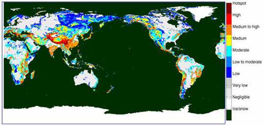
Landslide Hazard Maps

Because of the threat that landslides pose to human life, many government agencies maintain landslide hazard maps. These show where landslides have happened in the past and the probability of landslides happening in the future. Homeowners are advised to check these maps before constructing or buying a new home in steeply-sloped mountainous areas. If you do decide to live in a landslide-prone area, watch out for the warning signs that a landslide could occur, including:
- soil moving away from foundation, and
- ground that is not usually wet becoming saturated with water.
What do you think makes the biggest difference between the white (very low landslide risk) and red (very high landslide risk) areas on the world map?
Red areas are highly-sloped mountainous areas and/or areas that have heavy seasonal rains. For example, the high risk area in central Asia represents a mountainous area prone to monsoonal rains. White areas are relatively flat land where mass movement is less common.
In this podcast from the U.S. Geological Survey, you can listen to scientists discuss the impact of wildfires on a California landslide. As you listen, answer the following questions:
- Why do fires increase landslide risks?
- How does tracking wildfires aid scientists in developing landslide hazard maps?