Influences on Climate
You have just learned that climate is a description of the average long-term expected temperature and precipitation values for an area. But what determines what those values are, and why are they usually so predictable? There are six main influences on climate that you will learn about. They are: latitude, wind belts, closeness to oceans, position relative to mountains, altitude, and albedo. Click each image below to learn more.

Latitude: Remember that latitude is a measure of distance north and south of the equator. Remember also that the equatorial latitudes take in much more solar radiation than do the polar latitudes of the globe. This results in a radiation surplus near the equator and a radiation deficit at polar areas. This explains why tropical areas near the equator are hot and polar areas are cold, and why areas in between are generally seasonal or temperate. This map shows you how temperature varies with latitude.

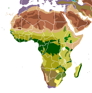
Wind Belts: You learned about atmospheric circulation cells earlier in this unit, and how they form as air circulates by rising and sinking motions. Warm air from the equator rises because it is lighter than cooler air. As it rises, however, it begins to cool down. The air can hold less moisture when it is cool than it could when it was warm. Therefore, places where air rises, such as at the equator, have high levels of precipitation (because the air cannot hold on to its moisture as it begins to rise and cool). Conversely, locations where cool air begins to sink back down experience more evaporation than precipitation. These areas are dry or arid. The African continent is a good example of this. The green areas are near the equator and are characterized by plentiful rain and lush vegetation. The brown areas, especially those to the north, are characterized by dry descending air that cause deserts.

Closeness to an ocean: The world’s surface ocean currents travel in the same directions as the major wind belts, since the winds push the seawater. Ocean currents transport heat around Earth and influence climate. Areas near oceans typically have more moderate climates than do continental areas. This is because water absorbs and releases heat less readily than does land. Therefore, land has more extreme variations in its temperature than water, and oceans, because they are made of water, keep moderate temperatures year-round.

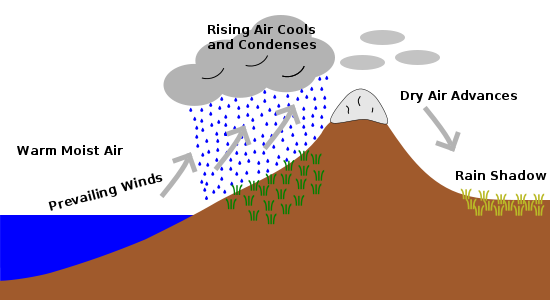
Position relative to mountains: This picture also illustrates how mountains affect climate. Notice how clouds pile up on the side of the mountain facing the coast. They let go of all of their moisture before passing over the mountain; the other side of the mountain is in the rain shadow and is much drier because of this.

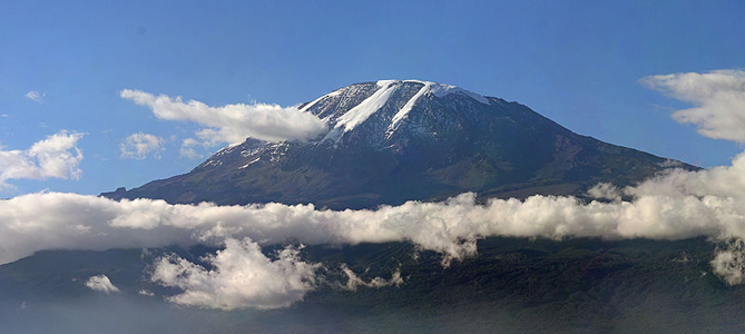
Altitude: Altitude is a measure of distance above sea level. Air temperature decreases with height above sea level. In the African country of Tanzania, Mt. Kilimanjaro rises more than 19,000 feet above sea level. It has icy glaciers at its highest peaks even though the land below it is swelteringly hot.

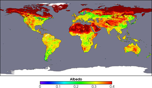
Albedo: Albedo is a measure of how much sunlight a surface reflects. Snow and ice reflect much more sunlight that forests and other vegetation. This contributes to polar areas being even colder. The map shows how albedo varies worldwide. Note that northern Africa has albedo levels almost as high as the higher northern latitudes. Why do you think this is so? Remember that this part of Africa is largely desert—sand reflects huge amounts of sunlight.
© KC Distance Learning. All rights reserved.


