Geologic History of the Earth
Two hundred million years ago, all of the continents were joined together as the supercontinent Pangaea. Pangaea was surrounded by a single ocean called Panthalassa which covered the rest of the planet. Approximately 180 million years ago, a new rift appeared between what would be North America, South America and Africa. This rift would become the Mid-Atlantic Ridge. As the rift developed and pushed apart these continents, the space between would become the Atlantic Ocean. Pangaea was now divided into two continents called Laurasia and Gondwana. Laurasia was made up of current day North America and Eurasia. Gondwana was made up of South America, Africa, Antartica, India and Australia. More rifts began to appear during this time, breaking up Gondwana, moving these continents further apart from each other as well.
About 135 million years ago, a rift occurred between South America and Africa. This rift continued to expand and eventually joined with the mid-ocean ridge in the North Atlantic form a single mid-oceanic ridge in the Atlantic. More ridges would form and further divide the remaining clumps of Pangaea over time to form the positions of continents as we know them today. However, this movement is not complete. The continents will continue to flow adrift the asthenosphere, colliding and reforming new landmasses only to break up and drift apart again.
Sediments in the ocean can provide a wealth of information for scientists about the history of our planet. Scientists can review lithogenous sediment, which is the sediment from the weathering of rocks, and biogenous sediment, which is the skeletons and shells of marine organisms. The fossils in ocean sediment can reveal information about the ocean temperatures at specific times in our history, giving clues about the Earth's climate and ocean currents.
The climate of Earth has fluctuated over its history. There have been interglacial periods, or warm periods followed by cold periods called ice ages. The Earth is presently in an interglacial period. During ice ages, large amounts of water trapped in ice as glaciers on land. Because water is trapped in this ice, less water flows into the oceans through streams and rivers and therefore the sea level is lower during these times.
Earth experienced its most recent ice age about 18,000 years ago. During that time, North America was covered in ice nearly 2 miles thick. Sea level at the time was approximately 425 feet lower than it is today.


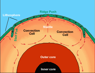
 The Earth's core heats the molten rocks of the mantle and causes it to move in a circular pattern called a convection current. The hottest molten rock rises toward the lithosphere, or crust, while the cooler molten rock of the mantle sinks back toward the core where it is heated. This cycle creates a convection current that was once thought to move the Earth's plates along like a conveyor belt. Although the convection currents may still have some impact on the movement of the plates, the most current view is that the movement is caused more by the sinking of dense oceanic crust. As the oceanic crust ages, it becomes cooler and more dense. Eventually, it will sink back into the mantle and in doing so, it creates a trench and pulls the rest of the oceanic plate behind it. This is called "slab pull". This pull causes the plates to separate at the mid-ocean ridges allowing fresh magma to rise to the surface.