Wind
 The most obvious way we experience atmospheric motion is by feeling the wind blow. Wind is caused by the movement of air resulting from pressure differences, which are in turn affected by temperature. Wind flows from areas of high air pressure to areas of low air pressure. (Air pressure is a measure of the amount of force that air exerts on a surface). Warm, rising air has lower air pressure than cold, sinking air.
When air cools over a cold surface, it develops high pressure, becomes denser, and sinks. A low pressure air system is formed in the opposite way—when air warms and rises. As air masses move around the globe, they come into contact with each other or border each other. If a pressure difference exists between them, air will flow as wind from the higher pressure area to the lower pressure area. The larger the pressure difference between two air masses, the stronger the wind between them will be. Click through the tabs below to learn more about wind.
Local Breezes

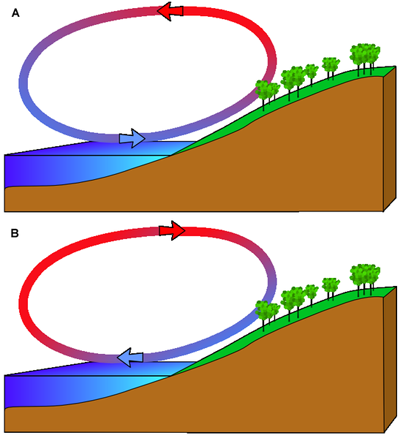
Winds vary in range, from local breezes to large-scale global winds that move around the globe in predictable patterns. This diagram shows one example of how local breezes form. Though it illustrates the formation of winds on coastal areas, the process is similar in other areas too. In the top image is the formation of what is called a sea breeze. Sea breezes form during the day in the following conditions:
- the land heats up faster than the water
- the air above the land then becomes warmer and rises
- the air over the water is cooler, so it develops a higher air pressure
- the air over the water moves inland toward the lower pressure, creating a sea breeze near the coast
In the bottom image is the opposite effect, called a land breeze, which takes place at night under the following conditions:
- the land cools off more quickly than the water
- the pressure over the water is now lower than that over the land
- the air moves from the land to the water (or from higher pressure to lower pressure)
Mountain and Valley Breezes

During the daytime, the Sun warms the ground next to a mountain slope. Through conduction, the air just above it warms too. Cold dense air then settles down on the warm air, forcing the warm air up the mountain. This creates a breeze that blows from the valley up the mountain slope, and it is called a valley wind. At night, the opposite happens. Cold air from the top of the mountain moves down the slope, creating a breeze that blows from the mountain to the valley, called a mountain breeze.
Prevailing Winds

Wind and the Landscape
 Wind has an important effect on the landscape. This rock has been weathered down by blowing winds. This type of activity is called wind erosion.